
Page 238 - Dubai Universal Design Code
P. 238
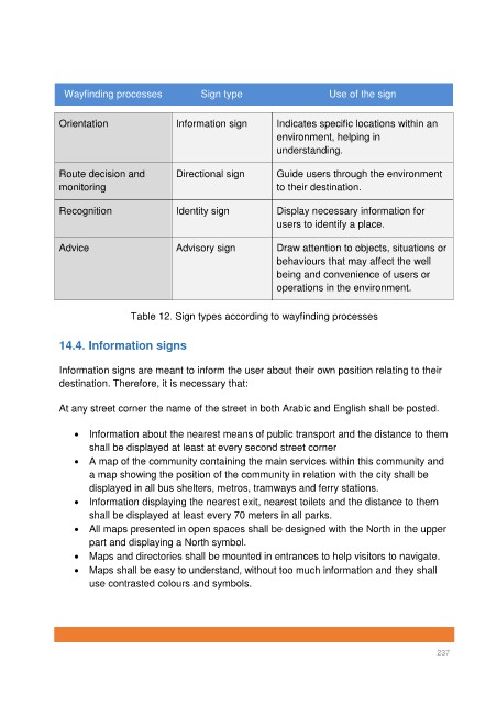
Wayfinding processes             Sign type                      Use of the sign


               Orientation                 Information sign        Indicates specific locations within an
                                                                   environment, helping in
                                                                   understanding.


               Route decision and          Directional sign        Guide users through the environment
               monitoring                                          to their destination.

               Recognition                 Identity sign           Display necessary information for
                                                                   users to identify a place.


               Advice                      Advisory sign           Draw attention to objects, situations or
                                                                   behaviours that may affect the well
                                                                   being and convenience of users or
                                                                   operations in the environment.


                                Table 12. Sign types according to wayfinding processes


               14.4. Information signs


               Information signs are meant to inform the user about their own position relating to their
               destination. Therefore, it is necessary that:


               At any street corner the name of the street in both Arabic and English shall be posted.


                   •  Information about the nearest means of public transport and the distance to them
                      shall be displayed at least at every second street corner
                   •  A map of the community containing the main services within this community and
                      a map showing the position of the community in relation with the city shall be
                      displayed in all bus shelters, metros, tramways and ferry stations.
                   •  Information displaying the nearest exit, nearest toilets and the distance to them
                      shall be displayed at least every 70 meters in all parks.
                   •  All maps presented in open spaces shall be designed with the North in the upper
                      part and displaying a North symbol.
                   •  Maps and directories shall be mounted in entrances to help visitors to navigate.
                   •  Maps shall be easy to understand, without too much information and they shall
                      use contrasted colours and symbols.


                                                                                                          237